"Chicago" by Carl Sandburg

Hog Butcher for the World,
Tool Maker, Stacker of Wheat,
Player with Railroads and the Nation's Freight Handler;
Stormy, husky, brawling,
City of the Big Shoulders

-excerpt from the poem "Chicago" by Carl Sandburg (1916)

Chicago Skyline

Chicago Skyline
The Chicago Skyline from a Near West Side highrise

Tuesday, March 22, 2011

Bucktown

The Breakdown
Modern mixed with old-school in Bucktown.
The boundaries: Bucktown is a neighborhood within the community area of Logan Square.  Although Bucktown is seemingly always connected with Wicker Park (they share a Chamber of Commerce as well), Wicker Park is actually located within the West Town community area.  The unofficial but commonly accepted triangular boundaries of Bucktown are Western Avenue to the west, Bloomingdale Avenue to the south, and the Chicago River to the northeast.  Some say the northern boundary ends at Fullerton Avenue, instead of where Western and the Chicago River meet.

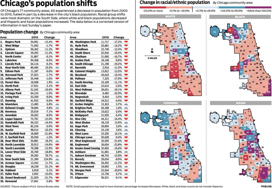
Population make-up: Hard to say officially.  As of the 2000 Census, the Logan Square community area was 26.3% white alone and 65.1% Hispanic.  However, Bucktown makes up less than half the geographic area of Logan Square (the eastern portion), and is bordered by mostly the majority-white community areas of Lincoln Park and North Center.  Also its equally trendy cousin, Wicker Park, borders it to the south.  Meanwhile, the remainder of Logan Square is bordered by the community areas of Hermosa, Avondale, and Humboldt Park, which are predominantly Hispanic in population.

Despite recently becoming a popular area for young professionals, Logan Square’s population dropped 12% from 2000 to 2010, from 82,715 to 72,791.

A brief history: Bucktown became a part of Chicago in 1837 and the land was purchased in 1870, along with a soon-to-be appropriately named land just south of it, by Charles and Joel Wicker.  The neighborhood grew to be an eclectic mix of nationalities: Germans, Eastern Europeans, Scandanavians, and Africans.  Its odd name supposedly comes from the numerous goats (a buck is a male goat) that were raised by early Polish settlers of the area.  Today it has become a very popular neighborhood for young professionals and hipsters alike.

Getting there: Rail won’t get you to the heart of Bucktown (basically Damen and Armitage), but it’ll put you within walking distance.  You can take the Blue Line to Western, but remember there are TWO Western stops on the Blue Line.  Make sure to get off at the one on the O’Hare branch and not the Forest Park branch.  The Western-O’Hare Blue Line stop will put you on the western edge of the neighborhood.  You’ll only be about two blocks south of Armitage.  You can also take the Metra to Clybourn.  Two Metra lines stop here, the Union Pacific North and the Union Pacific Northwest.  This stop will put you on the east side of Bucktown about one block south of Armitage.

Of course, bus is always an option too.  Going north-south, the Damen bus (50) runs through the center of the neighborhood.  Also going north-south is the Western bus (49) and there are a couple stops on the Ashland bus (9).  Going east-west the Armitage bus (73) runs through the heart of Bucktown.  Also, there are the buses along Fullerton (74) and Diversey (76 – assuming you’re considering that stretch of Diversey a part of Bucktown).  There is also a northwest/southeast bus along Milwaukee Avenue (56).

Tuesday, March 15, 2011

Albany Park

The Breakdown
The golden dome of Our Lady of Mercy Catholic Church
under renovation. 
The boundaries: OK, try to follow me here.  The community area of Albany Park is bordered by the Chicago River to east and mostly to the north as well.  To the south, the majority of its border is Montrose Avenue.  Once Montrose hits Elston Avenue, Albany Park's south and western boundary follows Elston to Lawrence Avenue.  Lawrence then runs into the Edens Expressway (I-94), which makes up the community area's western boundary.  Please refer to the map at the end of the post for a visual representation.


The majority of the community area is made up of the Albany Park neighborhood.  However, there are two smaller neighborhoods to the west, Mayfair and North Mayfair.  Both neighborhoods are bordered by Cicero Avenue to the west and Pulaski Road to the east.  Lawrence divides the neighborhoods, with North Mayfair going north to Bryn Mawr Avenue, and Mayfair going south to Montrose.


Population make-up: Unfortunately we don't have the demographic breakdowns of each community area yet, but we're working on it.  Going by the 2000 Census however, it's verification of the neighborhood's diversity.  The 2000 population was 57,655 with 46.4% of the population reporting as "Hispanic/Latino alone".  Those described as "White alone" made up 27.5% of the population while Asians made up 17.7% of the populace.  It also registered the largest total population of Korean and Filipino residents of any community area.  As of the 2010 Census, Albany Park's overall population had declined 10.6% to 51,542 residents.


A brief history: A farming community shortly after the Civil War, Albany Park was annexed by the explosively growing Chicago in 1889.  Albany Park experienced massive growth and development with the relocation of the Chicago River and the extension of the Chicago "L" to Kimball in the early 1900s.  Initially settled by German and Swedish immigrants, it became the home of a substantial Russian Jewish population into the 1960s.  Due to suburban flight, the area fell into great disrepair in the 70s.  Efforts in the 80s and 90s to rejuvenate the area have been successful, re-energizing the community.  Today, it is an incredibly diverse community of whites, Asians, Hispanics, and Asians.  It is home to a large contingent of Koreans, and it's estimated that nearly half the businesses along the Lawrence Avenue corridor are Korean-owned.


Lawrence Avenue in Albany Park hosts a high percentage
of Korean-owned businesses.
Getting there: Public transit is a reasonable option when getting to Albany Park.  The brown line serves the eastern half of the community area with stops at Kimball, Kedzie, and Francisco.  If going by bus, the east-west options are Lawrence (81) and Montrose (78).  The Foster bus (92) will also take you North Mayfair.


If going north-south, you can take the buses along Pulaski (53), Kimball (82), and partially by California/Dodge (93).  Also, the North Cicero bus (54A) will put you along the community area's western border.


Tuesday, March 1, 2011

2010 Census - Neighborhood Demographic Impact

Great information from the Chicago Tribune last week regarding the population of Chicago by community area.  As we already know, the City lost just over 200,000 residents from 2000 to 2010, almost a 7% drop.  However, it was interesting to see in which neighborhoods the City grew, and those in which population fell.