The Breakdown
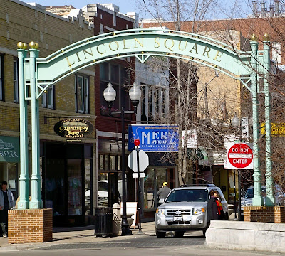 |
| The south entrance to Lincoln Square. Seriously though, DO enter. |
The boundaries: The community area of Lincoln Square is bounded by Montrose Avenue to the south, Ravenswood Avenue to the east, and the North Shore Channel (that leads into the Chicago River) to the west. The western half of the northern boundary is Bryn Mawr Avenue, between the North Shore Channel and Western Avenue. From there, Rosehill Cemetery makes up the northeastern portion of the community area, extending along Peterson Avenue from Western to Ravenswood.
The neighborhood of Ravenswood is located mostly within the Lincoln Square community area. There doesn’t seem to be definitive consensus on the boundaries, but according to the (now defunct?) Ravenswood Chamber of Commerce, it’s Leavitt Street to the west, Clark Street to the east, Foster Avenue to the north, and Montrose Avenue to the south.
Population make-up: At the 2000 Census there were 44,574 residents living in Lincoln Square. This has dropped to 39,493 in the 2010 Census, an 11.4% decrease. In 2000, the ethnic make-up was 67% white, 26.5% Hispanic, and 13.5% Asian. According to the
Chicago Tribune’s Census analysis, the White and Black populations have increased while the Hispanic and Asian populations have decreased in the past ten years. German was the largest population of ancestry in 2000, with over 5,600 Lincoln Square residents being of German descent.
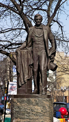 |
"Free society is not,
and shall not be, a failure."
-Abraham Lincoln, Chicago (12/10/1856) |
A brief history: If you had to guess the largest ancestry population in Chicago, you’d think it’d be Polish, right? Wrong. How about Irish? Try again. Italian? Nope, it’s actually German and Lincoln Square is
Chicago’s Little Munich. As in many Chicago neighborhoods, it
began as an agricultural area. Meanwhile, Ravenswood established itself after the Civil War as an
exclusive suburb. With the construction of the elevated train system, the area reaped further benefits in the early 1900s. An industrial corridor along Ravenswood Avenue soon came to be, and much of the street still is still home to light industrial companies. Post-World War II saw Lincoln Square being to develop itself as a
commercial destination.
Some gentrification, along with great access to public transit, has made Lincoln Square an attractive neighborhood for families and young professionals. Still, one-fifth of the community area has been designated a
historic preservation district, meaning that even with future development, much of the historic character of the neighborhood will be maintained. The public square (Lincoln Square) for which the community area takes its name is located at the intersection of Lawrence, Western, and Lincoln Avenues. It contains numerous unique bars, shops, and restaurants, two of which will be covered in this entry.
Getting there: If you can get to the Brown Line, it’s a piece of cake. There are Lincoln Square stops at Rockwell, Western, Damen, and Montrose in Lincoln Square (the latter two stop in the Ravenswood neighborhood). To get to the eponymous square for which the community area is named, get off at Western. You can also take the Metra (Union Pacific/North Line) to the Ravenswood station.
By bus going east-west, you can take Foster (92), Lawrence (81), and Montrose (78). The Peterson Bus (84) also runs the northern border of Lincoln Square. Running north-south your Lincoln Square options are: California (93), two Western buses (49 and 49B), and Damen (50). Another option for Ravenswood is the Clark Bus (22). Going northwest-southeast, you can take the Lincoln Bus (11).

 So, why discuss this article? Well, the reasons are twofold: because two Chicago "neighborhoods" are listed in the top 25, and because one of these two is apparently the most dangerous "neighborhood" in the entire United States. Now, we use neighborhood in quotes because this study seems to create boundaries based upon data, rather than using geographically-designated neighborhoods or community areas. For example, the most dangerous neighborhood in America is a small northwest section of the much-larger Near West Side community area.
